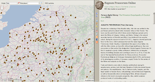
The Regnum Francorum user interface showing georeferenced articles of the Princeton Encyclopedia of Ancient Sites, with the embeded article of Augusta Treverorum (Trier) in the right pane.
The Regnum Francorum Online (RFO) historical GIS has recently been updated with a new user interface, built on Google Maps API 3.x. The GIS uses its own base tiles for zoom levels 6-10, made by the Mapnik software. These tiles are based on geographical data from OpenStreetMap (OSM) and the SRTM elevation data from NASA. It also contains basic historic information of the Late Roman civitates and early bishoprics of Western Europe, established until the 9th century, borders of the Early medieval counties (pagi) and the Roman roads network. Further geographical details can be viewed through the use of a collateral secondary map, covering zoom levels above 10, that is, embedded maps from OpenStreetMap (OSM), Google Maps (streetmap, terrain and satellite), the 18th century Cassini map of France, and an experimental topographical map covering the Moselle and Rhine regions of France and Germany, combining data from OSM and SRTM. The aim of the historical GIS is to compile evidence of places, institutions and territories from both primary and secondary sources, and render them as layers on top of the basemap. If the source editions are available online, the GIS will provide links to, or embed these sources into the historical GIS.
Recently, I have introduced tags of identifiers from certain external sources, that contribute to the definition of a place. These tags refer to entries in online encyclopedias (Wikipedia and the Princeton Encyclopedia of Classical Sites), topographical dictionaries (Toponymisch woordenboek) and gazetteers (Pleiades ancient places), as well as information from other geographical systems such as OpenstreetMap, Cartes IGN (France), and Google Satellite images. The tags regarding the latter, refer to manually selected archaeological features, whether or not archaeological remains are visible on satellite images (Google), or defined on the maps from IGN and OSM. In the case of Google and IGN, links are provided to embedded versions of these maps within RFO; in the case of OSM, an external link to the geometry entry at the OSM geographical database is displayed.
On the Sources menu tab in the Regnum Francorum Online application, there is a row of buttons that enables direct access to the layers described above. The layers showing georeferenced source editons and literature, the first two buttons, are not new, they have been components of the Regnum Francorum GIS for a long time. From inside the RFO application, one or more layers can be loaded simultaneously. Only the topmost layer is interactive, however, the order of layers can easily be altered fromthe Layers menu tab. These are the new layers:
A few examples

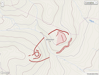
Below is the outcome of a click on a place called Heidetränk, located in Oberursel (Taunus) in Hesse, Germany, where there are extensive remains of a large Celtic oppidum. The image to the left is from the collateral map of the Moselle-Rhine region at zoom level 14. Normally, the archaeological sites in OSM display at zoom level 16 and above, but since this experimental map is intented to serve as a historial / archaeological basemap, their apperance is defined differently. The Heidetränk oppidum is defined in OSM by a series of polygons. Below are links to their entries in the OSM database. There are also links to articles in the German Wikipedia and the website Oppida : the first town north of the Alps, and a link to the Heidetränk entry in Pleiades Ancient Places gazetteer.
area: 130 ha; oppida=72; osm:way=137701370; osm:way=26535643; osm:way=27823337; osm:way=80406240; osm:way=89669777; osm:way=89671720; osm:way=89671727; osm:way=89671731; osm:way=89671773; pleiades:places=109038; wikipedia:de=Heidetränk-Oppidum

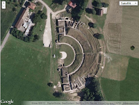
Below is the outcome of a click on a place called Mandeure, département Doubs, France, once a roman vicus, a small town with the remains of a theater. The image to the left is from the collateral Google satellite map at zoom level 18. The outline of the theater is defined in OSM by a polygon. There is also a link to an article in the Princeton encyclopedia of classical sites, which can be embedded in RFO, links to two articles in the French Wikipédia, a link to the Pleiades gazetteer, and finally a link to the embedded Google satellite image indicated by the satellite=yes link (this link is deactivated here).
geonames=2996251; osm:way=37846050; pecs=epamantadurum [embed]; pleiades:places=177516; satellite=yes; wikipedia:fr=Epomanduodurum; wikipedia:fr=Théâtre_antique_de_Mandeure
Following the link to OpenStreetMap where the polygon of the theater is defined, will display the following image, which is made up by 15 pair of coordinates.


I am deeply in love with every single piece of information you post here. Will be back often to read more updates!
ReplyDeleteBuy Flat Earth Map